
Geoarchaeology and Environmental History
Research Cluster
|
The University of Stirling is internationally recognised for its geoarchaeology and environmental history research programmes that seek to understand the complex relationships between societies and environments in the past. Our focus is on environmental and cultural records in soils, sediments and landscapes. From these records we give historical depth to contemporary environmental issues, elucide long-term human interactions with environmental processes, contribute to discussions on cultural and national identities as they relate to environments and landscapes, and provide a foundation for natural and cultural heritage resources management. Nine full-time academic and research staff are active within this important research arena; we integrate with historians at Stirling through the Centre for Environmental History (CEH) and with research colleagues in different parts of the world including Scotland, Iceland, Greenland, Norway, Denmark, the Netherlands, Sri Lanka, Nigeria and Greece.
Our research is currently supported by NERC, AHRC, Leverhulme Trust, Carnegie Trust and Historic Scotland, with external research funding secured to 2011. We house the Stirling Micromorphology Laboratory for the manufacture and analyses of soil and sediment thin sections – http://www.thin.stir.ac.uk/ including advanced image analyses facilities and SEM-EDX. We are also home to the Virtual Landscape centre, recreating ancient and archaeological landscapes from integrated geomorphological, palaeonological and historical data sets. Published output in international peer reviewed journals is extensive and we contribute to national and international cultural heritage policy issues and initiatives through Historic Scotland, English Heritage and UNESCO. The CEH is also the foundation of the MRes in Environmental History and undergraduate taught units at all levels
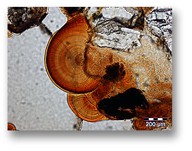
One key emphasis within our research group is in geoarchaeology – the understanding of soil- and sediment- based cultural records, where soils or sediments in the landscape retain relict and fossil soil properties associated with early human activity (anthrosols). Our recent innovative advances (part of the science-based archaeology research community) include theoretical frameworks of landscape and historical ecology, novel micro-analytical and micro-image analyses of soils and sediments in thin sections, soils biomarker analyses and process modelling of early soil-landscape-climate interaction. These advances are permitting new insights into land resource utilisation and organisation by early societies together with their environmental consequences and are complementing, enhancing and challenging documentary and archaeological sources. Projects on these themes have been based in such countries as Scotland, Iceland, Greenland, Norway, Denmark, the Netherlands, Sri Lanka, Nigeria, Chad and Greece. All projects involve collaboration with archaeologists and other environmental specialists.
|
Major current research projects include:
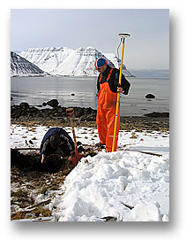
Footprints on the Edge of Thule.
The identification and interpretation of change in landscapes were Norse peoples met and interacted with indigenous communities. The project focuses on landscape interactions between Norse and Saami in arctic Norway and Sweden, and between Norse and Inuit in Greenland. In collaboration with Universities of Aberdeen and Edinburgh. Contact: Ian Simpson
Landscapes circum Landnám
This project explores the environmental impact, changes in environmental trajectories and adaptations associated with Norse settlement (from ca. 800 AD) of the pristine landscapes of Faroe, Iceland and Greenland. Key themes include the utilisation of fuel resources, the development, management and productivities of cultivated ‘home fields’ and the relationship between grazing pressure and land degradation in early rangeland areas. In collaboration with Aberdeen University, Edinburgh University, University of Bournemouth, University College London and City University New York. Contact: Ian Simpson
The Papar project
The Papar place names found in the Northern and Western Isles of Scotland are frequently a focus for early, Celtic, ecclesiastial settlement, with the name possibly given by Norse settlers to the ‘priests’ who occupied or used to occupy these locations. This project explores the landscape of papar places and considers the land use and land management changes that may have been introduced by the papar. In collaboration with Universities of St Andrews, and Glasgow. Contact: Ian Simpson
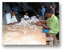
Anuradhapura, Sri Lanka: the Hinterland
Anuradhapura, located in the semi-arid area of Sri Lanka and a UNESCO World Heritage Site, emerged as a city from Iron age village origins in the 3rd century BC to become the capital of Sri Lanka until its collapse in the 12th century AD. In this project we explore the emergence and development of the irrigation system that supported food production for the city. Expressed in the landscape a series of tanks, bund and channels, issues of chronology, site formation and siltation are being addressed. In collaboration with Universities of Durham, Bradford, Leicester and Kelaniya. Contact: Ian Simpson
|
Geoarchaeology of late Pleistocene-early Holocene rockshelter sediments in Sri Lanka
Inhabited by anatomically modern humans since at least 40,000 BP, Sri Lanka has yielded some of the earliest reliably dated evidence of behavioural modernity in South Asia, comprising, among other, geometric microliths, explicitly symbolic articles of personal ornamentation and secondary burials. This evidence mainly comes from stratified rockshelter deposits in the humid tropical, southwestern part of the island. Preliminary micromorphological analysis of sediments from two key rockshelter sites yields insights on Late Quaternary environmental change linked with changing intensity of the SW Monsoon, the principal climatic driver in the region, and subtle aspects of late Pleistocene hunter-gatherer behaviour, ranging from exploitation of rainforest resources to on-site activities and organisation of inhabited rockshelter space. Linked with ongoing analyses of lithic technologies and faunal remains by colleagues from the Sri Lankan Department of Archaeology, our geoarchaeological work contributes to current discussions of the interactions between late Pleistocene human populations and their tropical environments, the temporal depth of human presence in the changing South Asian rainforest and, more broadly, environmental contexts of behavioural modernisation in late Pleistocene South Asia. On a more technical note, our work also contributes novel insights in processes of sediment deposition and postdepostional alteration within rockshelters in metamorphic bedrock. These insights are likely to be relevant in many similar settings in the low latitude world, where metamorphic terrains are widespread.
Contact: Ian Simpson
The development of a soil analysis support system for archaeologists (SASSA)
The aim of SASSA, funded by NERC as a knowledge-transfer project, is to provide support and training for curators and field archaeologists on the application of soil science techniques to archaeological questions. When complete it is envisaged that SASSA will provide: (1) Support for archaeologists in the field with recording and interpreting archaeological soils and sediments, (2) Guidance on appropriate field and laboratory analytical techniques relevant to answering archaeological questions, (3) Examples of the archaeological questions that soil analysis can contribute to, illustrated by case studies, (4) A background tutorial on soil concepts and geoarchaeology, (5) a glossary of soil terms and (6) a forum for interaction between archaeologists and soil scientists. Contact: Clare Wilson
|
Sahel region of West Africa
The Sahel region of West Africa is a semi-arid landscape on the southern fringe of the Sahara desert. Historical trading centres such as Kano, Gao and Timbuktu, are found in this region, each a terminus for trans-Saharan camel caravans to and from the Mediterranean coast. Today, as in past times, it is home to many millions of people with different cultural groups developing various ways of coping with the year-on-year changes in rainfall. With rain only falling during a few months each year, such strategies – from nomadic cattle herding to various types of farming - are extremely important. As in many semi–arid regions, bunds of earth are used to retain or channel water to specific fields. Archaeological survey coupled with geoarchaeological studies on the construction of these bunds, allows an insight to past water management strategies. Such geoarchaeological studies are therefore not only helping to build an understanding of the nature of these strategies, their development over time, but also in understanding change in today’s Sahel landscape. Contact: Paul Adderley
Mesolithic age vegetation change and hunter-gatherer impacts in eastern Scotland
This study seeks to identify through multi-disciplinary archaeological and palaeoecological analyses the driving forces in early-mid Holocene vegetation change. Extensive area excavation of a well preserved, waterlogged remnant of in situ woodland is supported by analyses of species composition, woodland structure and environmental change from plant macrofossil, palaeohydrological, palynological and palaeoentomological analyses. Contact: Richard Tipping
Landscape setting, ecological context and intervisibility within the Torbhlaren monument complex, Kilmartin, Argyll
We do not understand why open-air artistic forms were carved on rocks in the Neolithic period and early Bronze Age: nor do we know what these sites meant to the people who knew them. We are working alongside archaeologists from Southampton and University College, Dublin, and our part of this project will try to reconstruct from geomorphological, palaeoecological and pedological analyses what the landscape looked like close to and around rock art panels in the Kilmartin valley, whether the art was made within the ‘taskscape’ or away from day-to-day activities in special places, whether located within woodland or in clearings, and how accessible these places were. Contact: Richard Tipping.
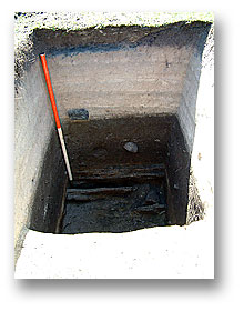
Past riverine evolution in a lowland agricultural landscape on Bute
Rivers are highly dynamic landforms, changing through external (climatic and anthropogenic) and internal forcing factors. Sediments preserved beneath floodplains and dated provide records of these changes. In this project we are engaging with and passing on our expertise to local communities on Bute who will discover for themselves the literally hidden landscapes of the past by systematic recording and radiocarbon dating of prehistoric and historic riverine sediments. Contact: Richard Tipping
Current PhD programmes include:
The emergence of early fishing communities in North-west Iceland, a geoarchaeology approach. (Stuart Morrison).
Historical perspectives on fish trade in Iceland. (Val Dufeu)
|
Inherited landscape: the pre-historic field systems of Shetland. (Val Turner)
Human and environmental dynamics in early modern Mývatnssveit, Iceland (Jennifer Brown)
Origin and abandonment of irrigation in the Anuradhapura hinterland, Sri Lanka. (Krista Gilliland)
Landscapes of Norse-Saami interaction: How does the emergence of trade sites influence neighbouring hinterlands? (Heather Green)
The nature and significance of black carbon particles in anthrosols, and their nutrient capabilities in contrasting rural occupation sites across North West Europe. (Ben Pears)
| Academic and Research Staff: | Research Students: |
Prof Ian A Simpson |
Enquiries
The group welcomes enquiries about projects or research studentships. Contact should be made with either Prof Ian Simpson (i.a.simpson@stir.ac.uk), Dr Paul Adderley (w.p.adderley@stir.ac.uk) or Dr Clare Wilson (c.a.wilson@stir.ac.uk).